|
"Old
evidence, partial interpretation"? Not a single piece of
evidence holds up that Chicxulub is older than the K/T
boundary
Keller et al's lengthy riposte of December 8, 2003
contains a few items of substance that I can comment on.
Those items remain important for the question that is at
hand here at the Geolsoc debate: is there plausible evidence
that the Chicxulub crater predates the K/T boundary?
1. Burrows in units 1 and 2
2. Significance of the "sandy limestone layer"
3. Multiple spherule layers
4. Foraminiferal evidence from Yaxcopoil-1
5. Keller et al's conclusions
In their last response (8 December 2003) Keller et al.
repeatedly mention (op cit.): "detailed empirical evidence",
"comprehensive evidence", "large body of contrary evidence",
" enormous amount of new data" "irrefutable evidence"
"empirical evidence …is multifaceted and very strong",
that would underscore the hypothesis that the Chicxulub
crater is older than the K/T boundary. However, time and
again all these "data" and "evidence" are interpretations,
not facts.
"The large body of contrary evidence…. to the K/T
impact-tsunami hypothesis" contains very little substance as
well.
However, I am more than willing to go back in the field
with a bunch of knowledgeable sedimentologists, (better
still, a truckload of curious and critical geology majors)
and discuss and unscrew in the field every bit and piece of
these "large bodies of evidence"
Communication is a difficult matter, and apparently I do
not get my message across to Keller et al. in a number of
instances. Keller et al. consistently (mis)read what I have
not written, or conclude what I have neither written nor
suggested. For instance, I wrote that only Mendez beds were
fluidized, yet Keller et al devote a whole section to argue
that I have written that the so-called "sandy limestone
layer" is fluidized, what I never did.
Also, I said in my riposte (ironically) that their "Fig
6b is not a "sandy limestone layer", but instead Mendez marl
clasts embedded in spherules". By this I meant that Keller
et al made the mistake by confusing the layers with marl
clasts and spherules with the hard "sandy limestone layer"
in their fig 6b, NOT me!
Another inconsistency: "Mineralogical data also
unequivocally show that these deposits are not tsunami
events". I fail to see that mineralogical data can replace
sedimentological field observations. What are the
unequivocal "mineralogical" data that are supposed to
achieve this? If Keller means clay minerals and other
phyllosilicates such as glauconite, Illite and smectite,
than I am amazed that she finds this clay mineralogical can
of worms "unequivocal evidence".
Keller in the same sentence writes: …"By definition,
glauconite is a poorly crystallized illite enriched in K and
Fe ……. And it is NOT an illite".
I am now totally confused, is it an illite or is it
not??
Another slip of the pen: "Smit denies that there are
multiple horizons of burrowing within the fine-grained
layers of unit 3 &endash; calling them scratches, wasp nests
and mud-filled rootlets". Instead I wrote "no burrows were
found in Mimbral in the lower levels of units 1 and 2, nor
in any other of the outcrops in eastern Mexico, but burrows
do occur in unit 3, near the upper part."
Furthermore, I have great reservations about the
definitions Keller et al use for the terms micrite, sand and
sandstone. I will try to clarify this terminological mess
further down.
Burrows in units 1 and 2
J-Shaped burrows.
Keller et al. write: "…. Smit reproduced these
images and absurdly claims that they represent mirror images
of one and the same burrow, one from the hand specimen and
one from the field outcrop. This is nonsense…"
Here Keller is playing poker, and I called her bluff. I
tried to say cautiously that Keller probably had multiplied
one "burrow" to look like four, and moreover, that in the
labeling she placed these four "burrows" in three different
units: 1, 2 and 3. Now Keller says that: "Smit is obviously
confused about the J-shaped spherule infilled burrows in
units 1 and 2. Contrary to his claim, we never found these
burrows in unit 3". That is not my claim, but Keller's, and
I assume she made an error in that figure 3b (reproduced
from Ekdale and Stinnesbeck, 1998). To clarify the subject,
I show here this figure (figure1), now with the labeling
from Keller's reply of 19 November in the
image.
|
|
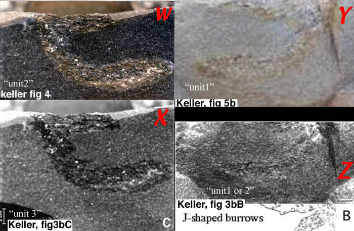
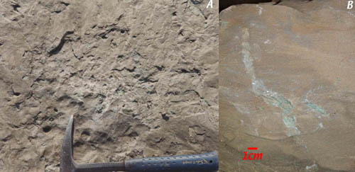
Figure1a
Figures shown in Kellers riposte of Nov 19 of a
J-shaped "burrow " from the "sandy limestone" from
el Penon. The labeling of the Units is from Keller.
It is clear that the four images are from the same
burrow-like structure. Images W-X are from the
counterpart of images Y-Z. Features such as grain
size both in- and outside the J-shape are the same
in each of the images, although that can be only
properly judged if Keller would submit a sharper
print of these images.
|
Images W and X are, feature by feature, clearly the same.
Similarly, Y and Z are the same, grain-by-grain,
crack-by-crack. W-X and Y-Z are almost certainly mirror
images, so I suggested that w-x is photographed from a
counterpart hand specimen, because Y-Z is photographed in
the field.
Am I wrong? I don't think so. Keller et al claim that the
"burrow" in unit 2 is twice the size as the one in unit 1.
Although the quality of images Y-Z is not the best (I hope
Keller will show a few better ones) the visible grain sizes
in the resized pictures from both the matrix and the
spherule filing of the "burrow" of w-x and y-z appear the
same.
I repeat here: All of these pictures strongly suggest
that they represent one and the same "burrow" (if it is a
burrow at all, what I contest), consistent with the
conclusions from ichnospecialist Tony Ekdale (Ekdale and
Stinnesbeck, l998): "that Unit 1 does not contain burrows in
any site, and that in Unit 2 only in Penon a few poorly
defined burrows occur, which could have been excavated very
quickly".
We very carefully searched the same outcrop (figure1b)
and found only one "burrow-like" feature (figure 1c), that
on close inspection turned out to be an iron-oxide lined
crack.
|
|
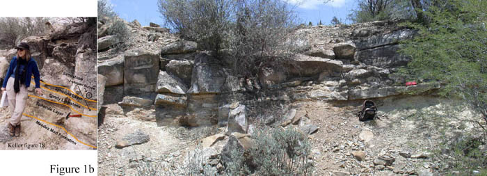
Figure 1b
Overview of the Penon outcrop showing a hard
calcareous sandstone (labeled by Keller et al as
Sandy limestone layer). Both Keller et al and we
have searched the layer (see inset) for burrows. We
found here (figure 1c) only one possible
burrow-like feature, which turned out to be a rusty
crack. (click on image for detailed view)
|
|
|
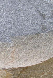
Figure 1c
Burrow-like feature in the hard sandstone of
figure 1b, that turned out to be a crack lined with
iron oxides
|
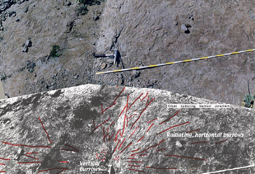
Keller et al. show nice burrows from the Rancho Canales
site (their figure16). My colleagues and I have also seen
these burrows and agree (!) with Keller et al that these are
burrows. However, our interpretations are clearly different.
I described (Smit, 1996) from the nearby site el Penon very
similar "glauconite" lined ophiomorpha burrows, which I
attributed to crabs/shrimps that were capable to burrow more
than 70cm deep into sandstone (figure2a-c). We observed at
el Penon more or less vertical bundles of tubes penetrating
from the bioturbated surface of the clastic beds (unit3)
(figure2c) to 70-100cm below the surface where the burrows
spread out horizontally in a radiating and bifurcating
pattern in one of the finer silt layers (figure2b). The
glauconite lined burrows Keller et al. show from Rancho
Canales are very similar to these vertical tubes from Penon,
and I assume also those at Rancho Canales penetrate up to
the surface of the unit 3 beds, although I could not observe
that due to overlying beds. They are probably not truncated
as Keller et al. claim.
|

|
Figure 2a
Block-diagram of unit 3 at el Penon, showing the
various ichnofabrics. The ichnofabric tiers in the
upper levels of unit 3 are diverse and contain
Zoophycos, Chondrites, Planolites and deeper
burrowing ophiomorpha-like structures. The vertical
bundle of tubes can penetrate up to 100 cm down
into unit 3 from the top of the clastic beds. These
vertical tubes are very similar to those as shown
in Keller et al's figure 16
|
|
|
Figure 2b
Images of the horizontal Ophiomorpha bifurcating
burrow-tubes radiating from the vertical bundle of
tube structures that reach 70cm up to the surface
of the clastic beds. (click on image for detailed
view)
|
|
|
Figure 2c
Close up of the vertical bundle of ophiomorpha
burrows. A) View on the bedding plane where the
bundle of over 20 tubes disappears to deeper
levels. B) Vertical cross section through a current
rippled bed of the top of unit 3, showing a few
"glauconite" lined tubes of a vertical bundle of
burrows
|
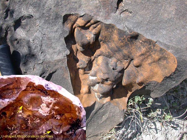
Keller et al. show in their figure 17 a few U-shaped
features from the base of the clastic beds at los Ramones.
They claim these to be "common U-shaped
Rhizocorallium burrow sticking out of the lower surface
of a sandstone layer…".
We have also observed these features (figure3a, b), and
conclude that these cannot be "rhizocorallium burrows" for
two reasons:
1. Rhizocorallium burrows are common in shallow water
coastal environments, and invariably occur at the top of a
sandstone layer. In other words, the Rhizocorallium animal
prefers to burrow into sand. At Los Ramones they occur on
the underside of sandstone layers. This means that if they
are Rhizocorallium, they first had to be excavated in the
underlying Mendez shale, and subsequently filled (as cast)
by the sand from the sandstone. This seems very unlikely
regarding their living environment. But even if these
features would represent burrows, they would then be of
Mendez (=upper Cretaceous) age, preceding the deposition of
the sandstone beds, NOT during the deposition of the beds,
and therefore irrelevant for the discussion.
2. The "Rhizocorallium burrow" shown by Keller et al. are
not burrows, but flute casts (figure3 a, b). We have
observed many flute casts at the Ramones locality, curiously
enough cast on the top of 10-50cm sized clasts of Mendez
shale. The large clasts are now eroded, so what remains are
the holes where they once existed, and the flute casts are
lining the holes. The u-shaped features we observed are all
flute casts, and although the figure17 of Keller et al. is
not the best quality, we assume that the U-shaped features
Keller et al claim to be Rhizocorallium are actually also
flute casts.
|
|
Figure 3a (click on the image for a more
detailed picture)
Flute casts gauged into a Mendez shale boulder
in the channels axis of the channel at Los Ramones.
The U-shaped flutes are reminiscent of the U-shaped
"burrow like feature" Keller et al show in their
figure 17 (inset)
|
|

|
Figure 3b (click on the image for a more
detailed picture)
Stereo pair of images of flute casts that
frequently show up on the Mendez boulders that
occur in the base of the clastic beds in the
channel axis at Los Ramones. We did not find true
Rhizocorallium at this lower level, but some
u-shaped burrows were observed at the rippled and
bioturbated top of the clastic beds at this
locality.
|
At last, Keller et al. claim that there is "a simple test
that can establish whether the burrowing community lived in
Tertiary sediments" because the burrows would be filled with
Tertiary sediments. "Tertiary" sediments are defined by
index fossils of Tertiary age, but it is well known that in
the first few thousands of years of the Tertiary, in the
base of the P0 zone, such Tertiary fossils do not exist yet.
Therefore, if the burrow-fabric in the top of Unit 3 was
formed at that time, before or during deposition of the base
of P0 -not unconceivable- than the burrows could not be
filled with Tertiary fossils. The "simple test" is therefore
not as simple as Keller et al. think.
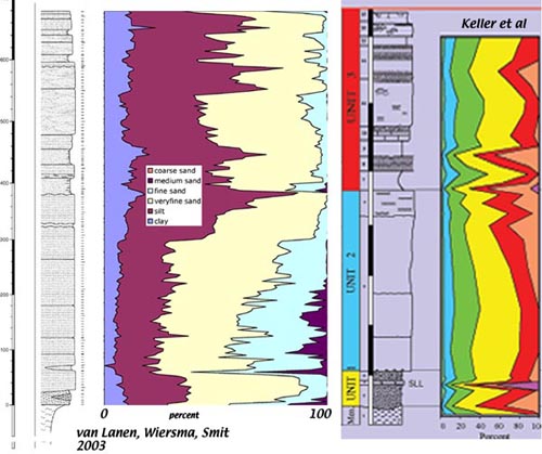
Significance of the "sandy limestone
layer"
Keller et al. claim that the so-called "sandy limestone
layer" is a hemipelagic limestone: "Hemipelagic limestone in
spherule unit 1………This SLL indicates that
spherule deposition within unit 1 occurred in two phases
interrupted by long-term hemipelagic sedimentation."
I strongly question that this sandy limestone layer is a
hemipelagic sediment:
1) It is a lithified sandstone, usually a grainstone,
with foraminifers and a few lithic grains as principal
components, sometimes with well-preserved spherules (Figure
4a,b)
2) Hemipelagic means that the components are derived from
the fine-grained pelagic rain, such as the hundreds of
meters thick adjacent hemipelagic Mendez and Velasco
formations. The "sandy limestone" is a laminated, sometimes
cross bedded and often channel filling sandstone, and
therefore completely different from the Mendez or Velasco
formations. That is confirmed by Kellers own granulometric
analysis shown in her figure 13 (figure4c)
3) Hemipelagic beds are, by their very nature, continuous
and continuous in thickness over large distances. The "sandy
limestone layer" is not even continuous over more than 10m
(cf. Figure1c)
|
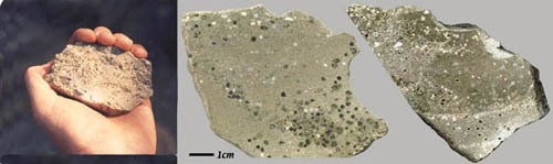
|
Figure 4a
Images of the "sandy limestone layer" at El
Mimbral, from the outcrop as described in Keller et
al. (1994) as such. This layer contains many
spherules with bubble cavities that are
characteristic for the impact glass particles at
the KT boundary in and outside the Chicxulub
crater. The white particles are limestone
fragments, probably also ejecta because these
co-occur only with the bubbly spherules. (click on
image for detailed view)
|
|
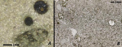
|
Figure 4b (click on image for a detailed
view)
Detail (A) and transmitted light thin section
image (B) of the "sandy limestone layer" of the
location of 4a. Sand-sized grains, mostly planktic
foraminferal tests filled with a green clay
mineral, demonstrate that the limestone is a
calcarenite with a sparry calcite matrix, with
interspersed spherules (although these spherules
may not occur within similar layers in other
outcrops). Therefore this layer qualifies as
high-energy sandstone, not a hemipelagic limestone.
(click on image for detailed view)
|
|
|
Figure 4c
Laser grain size analyses of the clastic beds at
El Penon. The two analyses are quite comparable,
although there are differences in detail. The
"sandy limestone layer" (SLL) is clearly coarse
grained, and cannot be a hemipelagic layer.
|
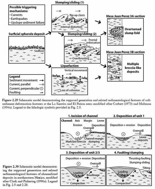
Multiple spherule
layers
Keller et al try to downplay the evidence for slumping
and soft-sediment deformation as explanation fo the
occurrence of multiple spherule layers. However, I am not
the only one that is aware of this widespread mechanism. I
reproduce here two figures (Figure 5) from the excellent PhD
thesis of Peter Schulte
(http://wwwrz.rz.uni-karlsruhe.de/~de57/Geo/Staff/Schulte/),
where he graphically displays a model for the deposition and
syn-sedimentary deformation of the clastic beds. I
completely underscribe his model, but one should be aware
that the situation may differ from outcrop to outcrop.
In my reaction to Markus Harting (17.12.03) I showed from
el Penon in Image 2 two "layers" of spherules, the lower one
inclined and discontinuous. Superficially, there are
multiple spherule layers in many outcrops in eastern Mexico
and the US Gulf coast (Brazos river, Moscow Landing), but
those layers are all discontinuous, and not separated by
normal hemipelagic Mendez layers. Digging a trench may
encounter such additional layers, but it is impossible to
verify any lateral continuity this way.
|
|
Figure 5
Coherent models for the deposition of the
clastic beds in the Gulf of Mexico. (from Schulte,
2003). These models are completely compatible with
deposition related to the Chicxulub impact and
related phenomena, such as earthquakes, tsunami's
and gravity flows.
|
Foraminiferal evidence from
Yaxcopoil-1
Keller still maintains that the rhomboid crystal forms
she showed in figure 22 are foraminiferal tests embedded in
a micritic matrix. Although Arz found some foraminiferal
tests in the same interval, they are not the same as the
ones shown by Keller; the features Keller shows are dolomite
rhombs. To support my argument I show here a few more
backscatter SEM micrographs from these, what Keller et al
claim, "micritic intervals" (figure5a).
|
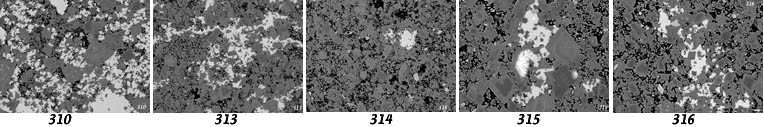
|
|
Figure 6a
SEM backscatter images of five samples from the
transition impact to post-impact rocks of the
Yaxcopoil-1 drill hole, drilled within the
Chicxulub crater. (Click on the sample numbers to
get a detailed image). If foraminiferal tests,
consisting of calcite, were present, they would
show up as light reflections just as the
interstitial sparry calcite.
(click on the images for detailed view)
|
In Figure6b the backscatter SEM image is combined with
X-ray Ka mapping of Mg, Si and Ca.
|
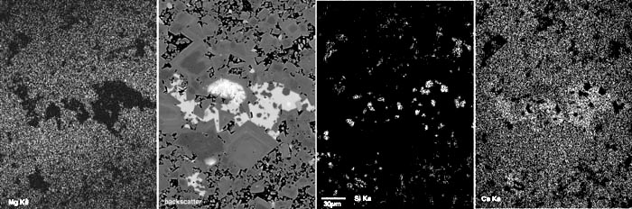
|
Figure 6b
SEM backscatter image of sample 315, with X-ray
Ka mapping of Mg, Si, and Ca of the same area. The
dark zoned rhomboid crystals are clearly dolomite.
The light areas are sparry crystals of calcite,
which fill the space between the dolomite crystals.
Hexagonal crystals within the calcite are
low-temperature quartz, diagenetically growing
inside the calcite.
The darkest areas between the dolomite and
calcite show Si Ka reflections, most likely
phyllosilicates, such as smectite, or "glauconite".
If micrite were present, it would show up as light
reflections like the calcite.
|
|
|
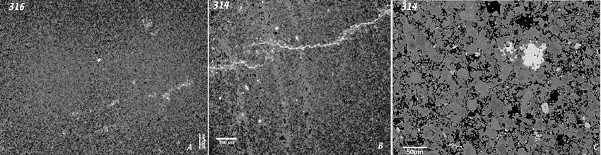
Figure 6c
SEM backscatter overview of samples 316(A), 314
(B), and enlargement of 314 (C). Dark areas are
dolomite, black areas are filled with
phyllosilicate, and light areas are calcite. The
light-grey areas are feldspar. (click on image for
detailed view)
|
|
|
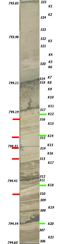
Figure 7
Image of the core-segment of the Yaxcopoil-1
drill hole that represents the transition from
impact to post-impact rocks. Smit (306-325) and
Keller (K1-K21) have analyzed samples labeled. The
red labels indicate the samples shown in figure 5a,
from similar levels as those analyzed by Keller
(green labels) and claimed by Keller to be rich in
foraminifers. As can be clearly seen on figure 5a,
no cross-sections of foraminifers are visible.
The interval 793.85-794.11m is uncontested
Paleocene micritic hemipelagic wackestone, rich in
Paleocene foraminifers. The interval 794.11-794.19m
represents a hardground, strongly burrowed. The
interval 794.19-794.60m represents cross-bedded and
parallel-bedded sandstones, mainly composed of
dolomite rhombs as can be seen in figres5a-c.
|
Micrite is defined as "an abbreviation of
'microcrystalline ooze', or as "microcrystalline calcite"
(Folk, 1959) or an "aggregate of CaCO3 crystals less than 4
microns in size", and in a wide sense as: "finely
crystalline calcium carbonate of almost any sort". As is
clearly shown on figure 5a-c, there is no micrite present,
and the vast majority of the grains are made of dolomite.
The whole texture of this interval 794.11-794.85 is one of a
coarse to fine sandstone, not of a pelagic micrite.
We can bring this round of the debate to a solution, by
performing a simple test.
Of all the levels I have sampled (figure6) polished thin
sections were prepared, and coated with carbon and analyzed
on the SEM and on the Electron microprobe. Those thin
sections are available to anyone who wants to look for
foraminifera and dolomite crystals, and with SEM in
backscatter mode it is easy to distinguish dolomite from
calcite. Foraminiferal tests are made of calcite, not
dolomite, and can be easily distinguished by this technique.
I don't know if Gerta Keller has prepared (polished) thin
sections without cover slip, but our technicians can easily
remove the cover slip, and polish the surface carefully
without destroying the thin section. After carbon coating it
should be an easy matter to relocate the "forams/dolomite
rhombs shown by Keller et al. in their figure 22 (and the
other plates she has shown on her website
http://geoweb.princeton.edu/people/faculty/keller/chicxpage2.html#28)
And distinguish the dolomite rhombs from a calcitic
foraminiferal test.
I hope someone will rise and act as impartial moderator
to perform this test.
Keller et al's conclusions (and
comment to each of those)
The age of the oldest Chicxulub impact ejecta spherule
layer in NE Mexico predates the K/T boundary by 300,000
years.
• "Evidence includes multiple spherule layers
with the oldest one near the base of zone CF1, which spans
the last 300 kyr of the Maastrichtian."
1) These extra layers are all anomalous and
discontinuous, and can be deposited in a time span
of<10years
• "The spherule layers are interbedded in
undisturbed bedded marls of the Mendez Formation, which
reveals the age of deposition. "
2) These Mendez beds are not
undisturbed.
• "Spherule layers are correlatable over great
distances."
3) Even the so-called basal original layer cannot be
correlated over more than ten
meters.
• "The stratigraphically lowest and oldest
spherule layer consists of almost pure spherules and only
rare clasts, which indicates rapid deposition after the
impact and no significant bottom currents."
4) The "lowest" layer is highly variable in composition,
and differs from outcrop to
outcrop.
• "Subsequent spherule layers contain variable
amounts of reworked clasts indicating erosion and
re-deposition."
5) Erosion and redeposition should be expected from large
tsunami waves, or tsunami triggered gravity flows, and are
not an argument pro or con.
• "The absence of major tectonic disturbance,
including major slumps, faults or fluidized
sediments."
6) The slumps and fluidization of the topmost Mendez beds
are there for all to see, in all localities with "multiple
layers" or oversteepened channel
walls.
• "The stratigraphically highest and youngest
spherule layer occurs just below the siliciclastic deposit
and is known as spherule unit 1. It contains the most
abundant reworked shallow water debris and mud clasts,
indicating transport from shallow shelf areas."
7) Backwash from a tsunami wave, or from a tsunami
triggered gravity flow (turbidite) is expected to bring
shallow water debris.
• "A sandy limestone layer within spherule unit 1
indicates that deposition occurred in two phases separated
by hemipelagic deposition. "
8) Nonsense. The " Sandy limestone layer", or
calcarenite, is current transported sandstone, not
hemipelagic sediment.
• "The K/T boundary, Ir anomaly and mass
extinction occurs above the siliciclastic deposit and
represents the true K/T impact event."
9) The iridium anomaly occurs in the top of the clastic
beds, not above. The mass-extinction coincides with the
deposition of the clastic beds, because there are no
Cretaceous hemipelagic beds above the clastic beds.
2. "The Chicxulub impact-tsunami hypothesis
is invalid"
This hypothesis was designed to explain the presence
siliciclastic deposit between the K/T boundary above it and
the Chicxulub spherule ejecta below. This hypothesis is
invalid for many reasons, but the major ones
include:
• There are various horizons of bioturbation
within units 1, 2 and 3 of the siliciclastic deposit, which
indicate repeated colonization of the ocean floor during
sedimentation and hence rules out a tsunami deposition
event.
10) Units 1 is devoid of burrows, unit two contains only
the one questionable "burrow" shown by Keller, which can be
explained, because it is so unclear, by various other
mechanisms (e.g. as a flame structure). The various levels
of bioturbation at unit 3 can all be explained by one
colonization episode after deposition of the clastic
beds
• There are various fine-grained layers, often
bioturbated within unit 3 that indicate normal hemipelagic
sedimentation alternating with rapid deposition.
11) These layers are all silty, and different in texture
from the underlying Mendez and overlying Velasco hemipelagic
marls, that represents the normal hemipelagic sedimentation
in eastern Mexico
• Two bentonite layers in unit 3 are correlatable
across NE Mexico and indicate periods of volcanic influx and
normal deposition.
12) That evidence solely rests on the occurrence of
zeolites, not an unequivocal volcanic indicator. Those
layers in unit 3 are also very different from the many true
bentonites that occur in the Mendez. It is no surprise to
find volcanic material in the clastic layers reworked from
those benthonites.
• A sandy limestone layer within spherule unit 1
is burrowed and also indicates a period of hemipelagic
deposition.
13) One burrow does not make a "bioturbation", and the
"sandy limestone (=calcarenite) is certainly not
hemipelagic
3. The age of the Chicxulub impact breccia at Yax-1
predates the K/T boundary.
Critical evidence is in the 50cm interval between the
impact breccia and the K/T boundary and includes the
presence of:
• Low energy laminated micrites and dolomitic
limestones between the impact breccia and the K/T
boundary.
14) This micrite (=usually nannofossil ooze) does not
exist, and the sandstone textures do not imply
low-energy.
• Four thin layers of glauconite formation within
this interval that indicates very low sedimentation over a
very long time (l05 yrs).
15) The glauconite particles are texturally very similar
to the bubbly altered tektites from all over the Gulf of
Mexico, and not a unique indicator of shallow water
environments.
• Bioturbation within these sediments that
indicates an active bottom dwelling fauna during
deposition.
16) Bioturbation is restricted to the interval
794.11-794.19m, and indicates a hardground at level 794.11,
indicating indeed missing
time!
• Late Maastrichtian planktic foraminiferal
assemblages of zone CF1, indicative of deposition during the
last 300Ka, similar to NE Mexico.
17) Plummerita hantkeninoides, the index for CF1, is
extremely rare in normal foraminiferal associations, and can
be distinguished from Rugoglobigerina by its delicate
spines. Even in well-preserved material it would be a
miracle that the spines are visible in thin section, let
alone in this dolomitic
sand.
• Palaeomagnetic chron 29r that marks the last
500Ka of the Maastrichtian.
18) No argument. All possible events occur in chron
29R
• Carbon isotope values characteristic of late
Maastrichtian sediments and without evidence of erratic
changes that would indicate reworking.
19) I question this interpretation. Carbon isotope values
are from either the dolomite crystals, or from the
well-crystallized interstitial diagenetic calcite.
• Absence of impact breccia clasts, or reworked
clasts from lithologies below the impact
breccia.
20) The glauconite pellets are from the impact
breccias.
• Absence of reworked fossils from older
sediments.
21) Arz et al found Albian
fossils
• Absence of high-energy deposition, backwash,
slumps, crater infill.
22) Those cross-bedded and parallel-bedded sandstones are
high-energy deposits
• Absence of Cheto smectite that would indicate
presence of altered impact glass.
23) Impact glass does not necessarily alter to
cheto-smectite.
All of these arguments raised by Keller et al can be
easily countered.
But Keller et al do not have an answer on the fact that
in coal swamp deposits over the entire US western Interior a
clay layer with iridium, shocked quartz and shocked zircon
with Chicxulub characteristics, lies directly on top of a
layer with spherules identical to those spherules in the
Gulf of Mexico even Keller et al consider as derived from
Chicxulub.
To squeeze 300kyr between those two amalgamated layers in
all Western Interior outcrops requires a bizarre
miracle.
Therefore, the K/T boundary impact and
the Chicxulub impact solidly remain one and the
same.
Ekdale, A. A. and W. Stinnesbeck (1998). Palaios 13(6):
593-602.
Keller, G., W. Stinnesbeck, et al. (1994). "Age,
deposition and Biotic effects of the Cretaceous/Tertiary
boundary event at Mimbral, NE Mexico." Palaios 9:
144-157.
Schulte, P., 2003, The Cretaceous-Paleogene transition
and Chicxulub impact ejecta in the northwestern Gulf of
Mexico: Paleoenvironments, sequence stratigraphic setting
and target lithologies [PhD thesis]: University of
Karlsruhe, 204 p.
Smit, J., T. B. Roep, et al. (1996). Geol. Soc. of Amer.
Sp. Pap. 307: 151-182.
[top]
|


