Chicxulub Drilling debates, Is the Chicxulub crater the KT boundary killer or Not? Still Smokin!!
Riposte of J. Smit on reply by keller on the reply by Smit on the lead by Keller (see the Geolsoc forum)
|
Chicxulub Drilling debates, Is the Chicxulub crater the KT boundary killer or Not? Still Smokin!! Riposte of J. Smit on reply by keller on the reply by Smit on the lead by Keller (see the Geolsoc forum) |
|
From the Geolsoc forum : A reply on the posted riposte by Keller 18 November 2003, but here are the full illustrations. The riposte by Keller of November 18 contains a handful of old arguments,to which I will add a few comments, correct a few errors, and provide some new information. I question the existence of so-called "strong evidence", in as much as this is interpretation rather than fact. Geological data in the field are often hard to interpret, in particular when dealing with a complex, poorly understood, clastic deposit. Gerta Keller consistently chooses to exploit only one explanation, and often fails to consider the alternatives. The items (I select the major ones) boil down to:
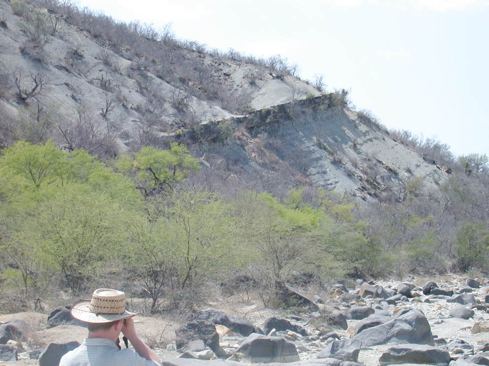
1) Multiple Spherule layers. Keller maintains that the alleged occurrence of multiple spherule layers below the the K/T boundary, imply that those are 0.3 myr older than the K/T boundary. Additional spherule layers were already observed during fieldtrips in 1991 with Pemex geologists (localities Cuauhtemoc, Sierrita (1)) when they showed us these outcrops. We tried to follow these "layers" but they continue only over short distances, and were slumped. Correlations of spherule layers I fail to see from Kellers figure 2 that these layers correlate, especially over distances >30 km and I am afraid many others have that problem too. Occurrence in Zone CF1 is not enough to correlate them layer by layer. In the area Mesa Juan Perez to Loma Cerca, (see Keller fig 1) all outcrops are strongly channellized. In the area between the isolated outcrops, the clastic beds probably do not occur, or are very thin. The presence of thicker beds holds up the mesas and hogbacks. In contrast, in the area from el Porvenir to el Mulato (fig a) where more planar beds are exposed over much longer distances, we have not observed any multiple spherule beds.
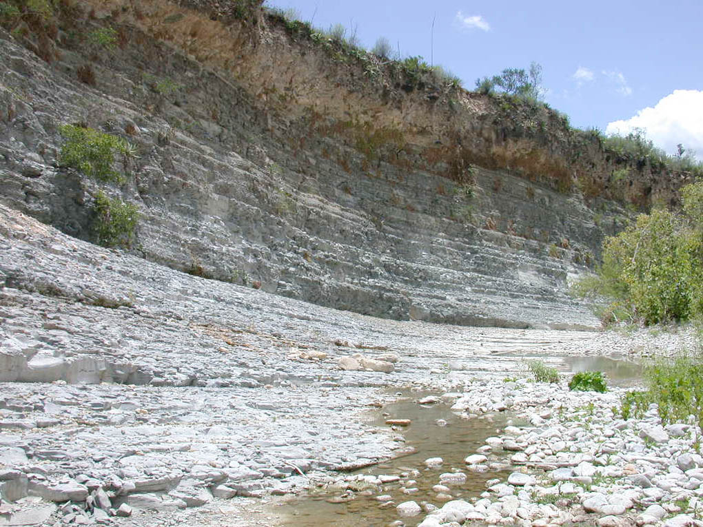
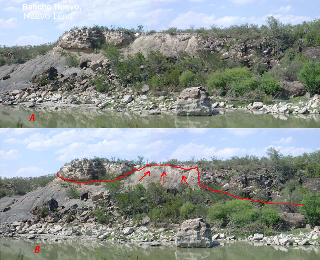
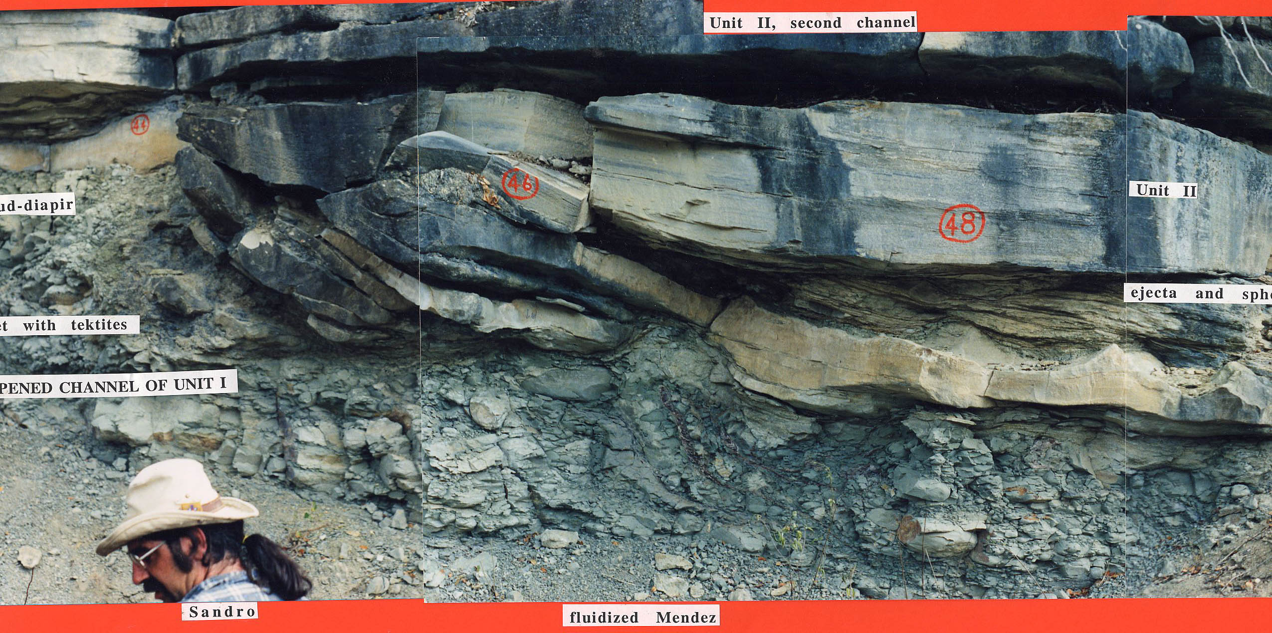
Hemipelagic sedimentation between spherule layers? The Upper Cretaceous Mendez shales show a well developed, probably rhythmic bedding (fig b)where the Mendez is better exposed. This bedding, however, disappears several meters below the clastic beds in many outcrops. Pure coincidence? We don't think so. These beds are fluidized probably due to ground shaking as result of the strong earthquakes from the Chicxulub impact. The fluidization depth differs probably from place to place, but is clearly visible at the Rancho Nuevo locality (fig c),but also in the classic Mimbral locality (figd), and minor in the Mulato area (fige).
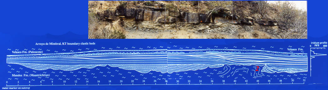
We have not observed "normal" hemipelagic sedimentation between the spherule "layers". There are often many layers composed of soft hemipelagic Mendez clasts, that are welded together, sometimes with preservation of internal burrows. These create the illusion of extended hemipelagic layers, as seen in figs f and g. (those are similar to Kellers figure 6b. Fig 6b is not a "sandy limestone layer" (see figd, same location as Keller's fig 6a), but instead Mendez marl clasts embedded in spherules). Of course these clasts are geochemically similar, and contain the same foraminiferal assemblages as Mendez marls below, they are reworked from slightly lower levels! The foraminiferal assemblages are consistent with CF1, but I fail to see consistent variations within the CF1 zone that would identify a lower or upper part. If such were the case, I would expect that micropaleontologists would create two zones, which has not happened.In the Mimbral outcrop (fig h), which is one of the few outcrops which is sufficiently well exposed to follow the individual layers, lateral aggradational channel-fill layers alternate between spherule-rich and clasts-rich. Elsewhere, e.g. in the Sierrita area, such channels can apparently reach large sizes and depth, in particular if the channels are deeply loaded into the fluidized marls as seen in Rancho Nuevo (figc). Those outcrops. However, are all covered by surface gumbo and debris, and therefore such details can be missed.
Burrows
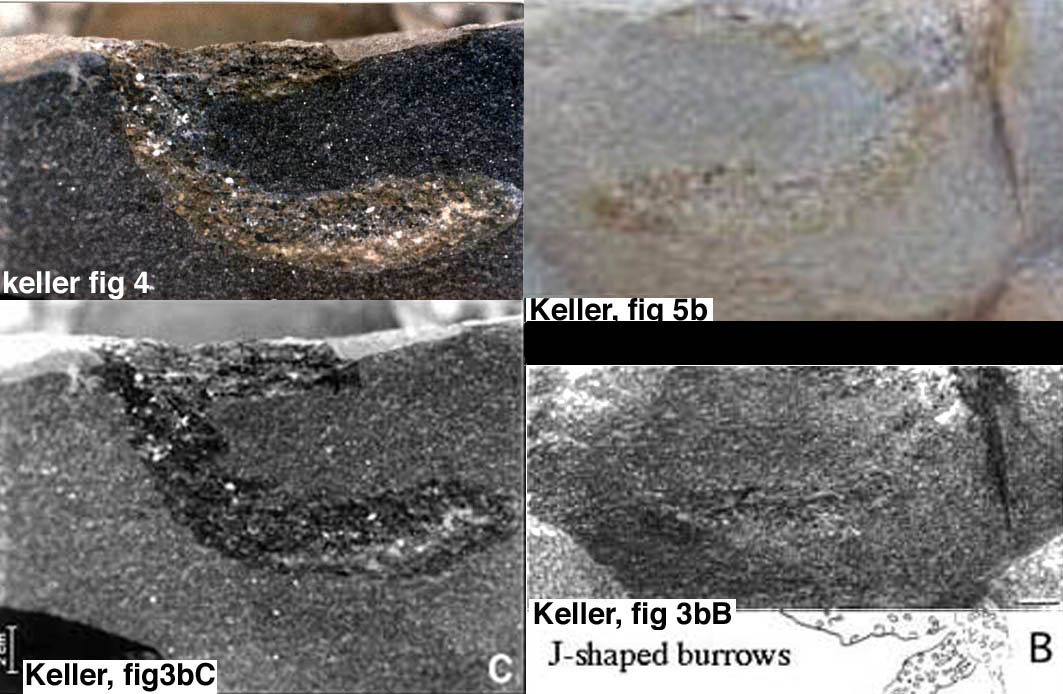
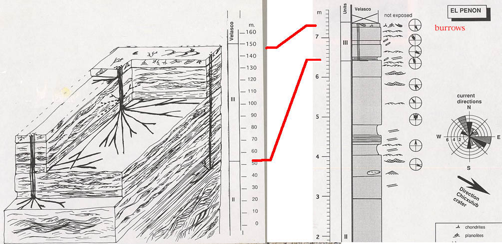
A major issue in this debate is the interpretation of burrows and burrow-like structures in the clastic beds at the K/T boundary in the Gulf coast outcrops. As we said earlier we believe that Keller got confused in several ways here. In Figure i we show where the different types of burrows and the burrow-like structures occur in the clastic beds. We strongly question the occurrence of burrows in the lower part of the clastic beds. One swallow does not make a summer, and one burrow-like structure does not produce a colonized, bioturbated surface. Lets first try to clean up some confusion in Kellers presentation of the "burrow" evidence. Can it be that the burrows shown by Keller in Fig 4, fig3bB, fig3bC, fig5b, all depict the same "J-shaped burrow-like structure" ?.
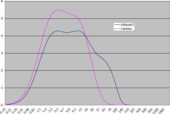
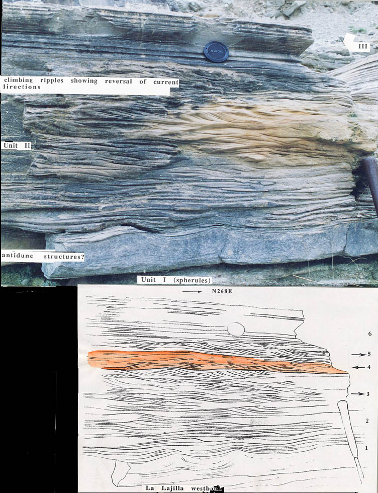
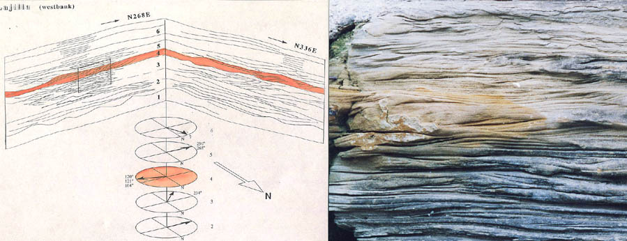
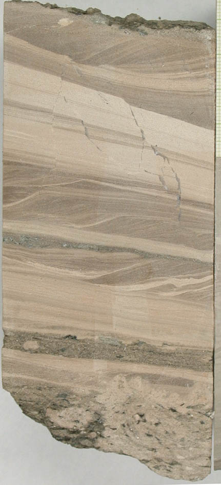
I regrouped all these figures here in one figure J, resized to the same size. Figs 4 and 3bC appear counterparts of figs 3bB and 5b. This way it is easy to multiply the 'evidence' of burrows. This J-shaped feature, is first described by Keller from Unit 2(fig4), then from Unit 1 (fig5b), then from Unit 3 (fig 3bB, subscript). If this feature is derived from Unit 3, (unlikely due to the presence of spherules) then I have no problem with its occurrence, since many burrow types occur in this unit. If correct, it would eliminate all the evidence for the presence of burrows in the lower part of the sequence, where, as I said earlier, my students, colleagues and I were not able to find burrow structures in several fieldtrips. Even world-renown experts can make mistakes, and Tony Ekdales find during the LPI excursion in 1994 of burrows in unit 2 in the Mimbral outcrop was there shown to be tubes of muddy sand, filled by plant-roots. This is a common feature of caliche soils in the area. Ekdale later referred to these as Holocene "Rhizocretes" (2), p594), and he added that Unit 1 does not contain burrows in any site, and that in Unit 2 only in Penon a few poorly defined burrows occur, "which could have been excavated very quickly". Possibly even between arrival of two tsunami waves, estimated by Bourgeois (3) to arrive an hour apart?. Subsequently, no burrows were found in Mimbral in the lower levels of units 1 and 2, nor in any other of the outcrops in eastern Mexico, but burrows do occur in unit 3, near the upper part. Disconformities and Current directions. Erosional disconformities are used by Keller to argue for prolonged deposition. I fail to see the validity of that argument, because successive turbidites or tsunamites can erode easily into the earlier deposited layers. In fact, it would be a miracle if that would not have happened. I would rather turn the argument around. If there were longer time spans involved, I would expect that normal, hemipelagic sediment like the Mendez, would have been deposited during that time between the sandstone layers, and at least be preserved in some of the 40 localities involved. Yet there is none. The levels Keller consistently calls 'normal pelagic sedimentation' between sandstone layers are, according to the grainsize analysis we performed, more silty than the true Mendez layers below the clastic deposit (fig k)At Coxquihui, where Keller mentions a Paleocene hemipelagic layer between two spherule layers, a fault intersects the section. Current directions measured by us (4, 5) often show current reversals (fig L, fig m)
However, the layers showing "upstream" i.e. N300-N30- directions, are thinner, probably because the backwash current was stronger, longer lasting , consistent with an interpretation as turbidites modified by tsunami waves. It is no surprise that Keller finds 94 out of 97 measurements in S90-S180 directions, because it is much easier to encounter measurable current directions in the much thicker layers showing S90-S180 directions. Flute casts at the base invariably show "downstream " directions. The best preserved ripple-beds with current reversals occur in the Lajilla (1 and 2) outrops. The sandstone beds there are far from channellized, and are sheet-like over 400m. Therefore, an explanation for the 180 degree different directions by channel-wall refraction/reflection seems unlikely.
2) Chicxulub Yaxcopoil-1 core interval 794.11-794.60m
Keller's interpretation that the interval 794.11-794.60m, just above the suevitic ejecta is Cf1 in age is based on three items: 1) foraminifers, 2 ) magnetostratigraphy, 3 ) late Maastrichtian isotope values. 2 ) and 3 ) are not contested, but offer no solution: 2) Chron 29R begins about 550kyr before and ends 250kyr after K/T (6). A reversed polarity of the 45 cm interval says therefore little about its age. 3) The limestone dolomite/limestone could be reworked Maastrichtian, no surprise that these have Maastrichtian isotopic values.
Foraminifera or dolomite crystals?
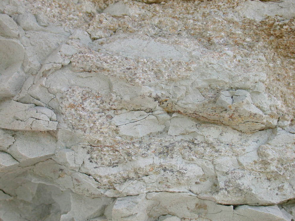
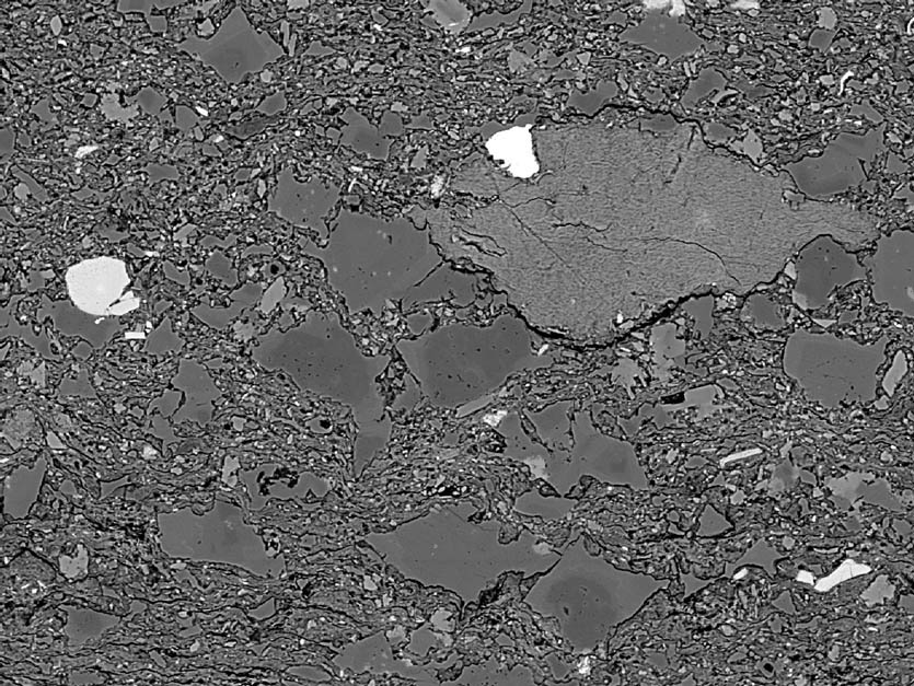
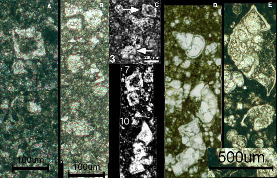
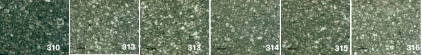
1 ) I strongly contest the interpretation by Keller that shapes shown in Keller's figure 9, (5-11) and on Keller's website (http://geoweb.princeton.edu/people/faculty/keller/chicxulub.html ) are foraminifers. In all the figures and plates shown by Keller not a single unequivocal foraminifer is visible, just fortuitous combinations of smaller and larger dolomite rhombs (fig n shows a SEM backscatter graph of such crystals, strongly corroded). Let alone that these 'forms' can be determined down to the species level, as Keller claims to be capable. I have looked, over 30 years, at hundreds of thin sections from the upper Cretaceous of the Scaglia Rossa of Italy, the Subbetic of Spain and I know how tricky it can be to determine species in thin sections. Even with perfect preservation, and with a lucky cross section species designation can be a gamble I rather abstain from. But I am curious to know how other foraminiferal specialists think about these. (SEM graphs of samples from these intervals forthcoming). Jose Antonio Arz has a split of exactly the same samples Keller has studied, and I have studied thin-sections of the same lithologies, I.e. laminated fine-grained dolomitic sandstone. It is not a question of looking at the right lithologies, they are simply not there, in any of the samples. (figo,
For sample levels used by Arz, Keller and Smit of the core, have a look at: the Chicxulub sample page Reworked microfossils? Keller says that the Yucatan platform does not support planktic foraminifers. Yet she mentions that planktic specimens of Cenomanian age are apparently present in Cenomanian rocks of the Yucatan platform. I suppose it is possible that these can rework into the cross-bedded sandstones.
Sandstone or Micrite? Keller employs a rather strange definition of a sandstone. Apparently she considers a rock a sandstone, when it consist of insoluble lithic grains, such as quartz. Yet sandstones can be composed of any type of coarse grains, including soluble limestone, as is the case here. What is visible in thin sections of the interval are alternations of coarser cross-bedded and finer grained laminated sandstone, composed of dolomite and limestone grains. Those will dissolve if put in acid. At some levels coarser traction carpets occur, loaded with green grains of clay, probably smectite-glauconite. The grains often display internal cavities, which we interpret to be inherited from gas bubbles in impact glass, because similar cavities occur in smectite pseudomorphs of spherules in the Gulf coast K/T outcrops. (fig p) Keller's figure 10 shows the rocks for what they are: sandstone. Fig q shows a picture of the cross-beds of the interval 794.54 794.41m., comparable with the Bouma Tc and Td intervals of turbidites. For more information about the entire interval, see http://www.geo.vu.nl/~smit/csdp/yaxcopoil/ejectapaleocene.htm
Glauconite or smectite? Keller argues that the presence of glauconite indicates long-term deposition, but her evidence is far from conclusive. Impact glass alters to various clay minerals, among which (cheto) smectite, illite, chlorite and glauconite are just a few examples. There are often many types of clay minerals, like Fe-Mg and K-bearing chlorite and illite phases (see Peter Schulte, 8) in the glass alteration phases in northeast Mexico. The green mineral shown by Keller is more typical for poorly crystallized illite or chlorite than the almost opaque dark green color of normal glauconite pellets. In textbooks like Deer, Howie and Zusmann, transformations from smectite to glauconite, a member of the illite group, have been described. The (altered) Chicxulub ejecta is compositionally very complex and does not only consist of smectite, but also of a large number of different clay-mineral phases derived form a mixture of more acidic and more mafic precursor rocks. Montanari (9) has shown alteration of K/T spherules in the Appenines ranging from smectite (Conero) to glauconite (Contessa), depending on the amount of tectonic stress. There is therefore no reason to interpret glauconite grains as forming at the sediment water interface, they could be alterations of impact glass.
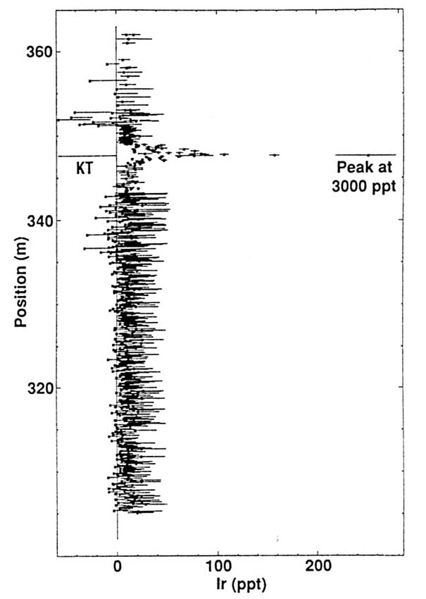
US Terrestrial sections? Keller argues that until now the sections in NE Mexico and in the Chicxulub crater were considered up till now the most complete. I wonder where that notion comes from, I argued that the most complete sections are far away from Chicxulub. Keller also argues that terrestrial sections are condensed and incomplete. Terrestrial sequences in itself are incomplete, as far as the channel and overbank facies are concerned, and those facies do not preserve thin volcanic ash and impact ejecta layers. Coal layers, on the other hand, preserve even the thinnest volcanic ashes. Most coal layers are free from dust and other clastic debris, and in quiet swamp environments the plant material accumulates continuously as long as the swamp remains. It is only in those fossil swamp deposits that we find the dual- K/T impact layers, from Alberta to New Mexico. In the Fort Peck lake area of eastern Montana for instance, the dual impact layer is preserved precisely at a major palynological turnover, in coal swamp deposits in the Hell Creek area , but not in the Bug Creek area, where the same palynological turnover is either eroded by major incised river channels, or occurs just below a coal layer in a overbank deposits. The upper, Ir-rich layer is best correlated with the global K/T anomaly in marine sections, because as far as we presently know (9, fig r) there is no second Ir anomaly in the 10ma straddling the K/T boundary. and the lower, spherule rich layer with the spherules from the Chicxulub impact. The age and origin of the shocked zircons in the upper layer are well explained by derivation from the panafrican basement of the Chicxulub crater.
Conclusions
Keller avoids the compelling implications of the dual layers in the K/T clay layer in the US western interior. She draws conclusions from the glauconite in the Yaxcopoil-1 core that are oversimplified. Keller argues for the existence of an abundant Upper Maastrichtian fauna in hemipelagic micrites above the suevite ejecta, where there are only dolomite crystals in sandstone. Keller multiplies artificially "evidence" to underscore the existence of a bioturbation, colonisation phase in the lower parts of the clastic beds in easterm Mexico, where there is only a single, poorly defined burrow-like structure in el Penon, among the over 40 sections analysed. Multiplets of spherule layers occur at different level only at those places where the clastic beds for deep channels and are deeply loaded into fluidized Mendez oozes. In conclusion, all of Kellers "evidence', when critically evaluated, evaporates one by one. We maintain that all the features of the K/T boundary, inside and outside the Chicxulub crater, call, with the present knowledge, for just one major impact event at the K/T boundary, and chances are that this is the Chicxulub impact event.
(1)Alvarez, W., Nishimura, J.M.G., Martinez, S.R., Ruiz, L.E., Guzman, R., Zambrano, M.J., Smit, J., Swinburne, N.H.M., and Margolis, S.V., 1992, The Cretaceous-Tertiary boundary impact-tsunami deposit in NE Mexico, Geol. Soc. Am. Ann Meeting: Cincinnati, Geol. Soc. Am, p. A331. (2) Ekdale, A.A., and Stinnesbeck, W., 1998, Trace fossils in Cretaceous-Tertiary (KT) boundary beds in northeastern Mexico; implications for sedimentation during the KT boundary event: Palaios, v. 13, p. 593-602. (3)Bourgeois, J., Hansen, T.A., Wiberg, P.L., and Kauffman, E.G., 1988, A tsunami deposit at the Cretaceous-Tertiary boundary in Texas: Science, v. 241, p. 567-570. (4)Smit, J., 1999, The global stratigraphy of the Cretaceous Tertiary boundary impact ejecta: Annual Review of Earth and Planetary Sciences, v. 27, p. 75-91. (5)Smit, J., Roep, T.B., Alvarez, W., Montanari, A., Claeys, P., Grajales-Nishimura, J.M., and Bermudez, J., 1996, Coarse grained, clastic sandstone complex at the K/T boundary around the Gulf of Mexico: Deposition by tsunami waves induced by the Chicxulub impact?, in Ryder, G., Fastovski, D., and Gartner, S., eds., The Cretaceous-Tertiary Event and Other Catastrophes in Earth History, Volume Sp. Pap. 307: Special Paper: Boulder, Geol. Soc. of Amer., p. 151-182. (6)Berggren, W.A., Kent, D.V., III, C.C.S., and Aubry, M.-P., 1995, A Revised Cenozoic Geochronology and Chronostratigraphy, Geochronology, time scales and global stratigraphic correlation, Volume Special Publication 54, SEPM. (7)Smit, J., and Klaver, G.T., 1989, Multiple impacts at the Cretaceous Tertiary (KT) boundary?: Terra Abstracts, v. 1, p. 421. (8) P. Schulte, The Cretaceous-paleogene transition and Chicxulub impact ejecta in the northwestern Gulf of Mexico: paleoenvironments, sequence stratigraphic setting and target lithologies. PhD thesis, Karlsruhe 2003 (9)Montanari, A., 1990. Authigenesis of impact spheroids in the K/T boundary clay from Italy: New constraints for high-resolution stratigraphy of terminal cretaceous events. Journal of Sedimentary Petrology, 61(3): 315-339. |
|
Look here for the Yaxcopoil-1 core segment 793.85 to 794.60 m: the transition of the impact to post-impact crater infill, |
back to top
![]()
![]()
.jpg)