 |
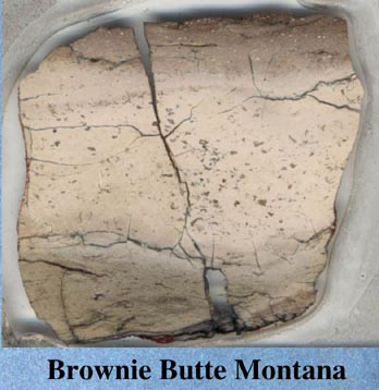
Brownie Butte, Hell Creek area near fort Peck lake, Montana The upper layer contains shocked quartz and iridium, the lower layer shards and fragments of spherules, that have been completely altered to clayminerals
move cursor over image, arrow points to the boundery between the two layers |
|
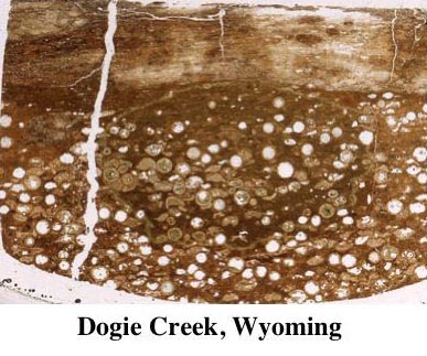 |
Dogie Creek, near Lance Creek in Eastern Wyoming. The lower layer here consists of clearly visible spherules, that have all the characteristics of the Chicxulub impact spherules, but have been completely altered to goyazite (the rim) and the interior is either dissolved, or filled with calcite. The upper layer is rich in shocked quartz and Zircons and contains an iridium anomaly move cursor over image, arrow points to the boundery between the two layers |
|
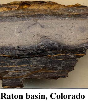 |
Madrid Railroad outcrops, west of Trinidad,
Colorado. The dark, lowest layer is low-grade coal, upon which rests a grey, 2cm thick layer of tonstein, composed of clayminerals with sparse "ghosts" of impact spherules. the upper layer, as elsewhere, is rich in iridium, shocked quartz and zircons. the shocked zircons in the upper layer reveal two ages: One from the time of impact shock (about 65 million years) and another of the age of the continental crust hit by the impact (about 550 million years). As the subsurface of Chicxulub has the same age (pan-african crust) it is highly unlikely that this upper layer is not derived from the Chicxulub impact. Krogh, T. E., S. L. Kamo, et al. (1993). "Fingerprinting the K/T impact site and determining the time of impact by U-Pb dating of single shocked zircons from distal ejecta." Earth and Planetary Science Letters 119: 425-429. |
|
| back to top | ||