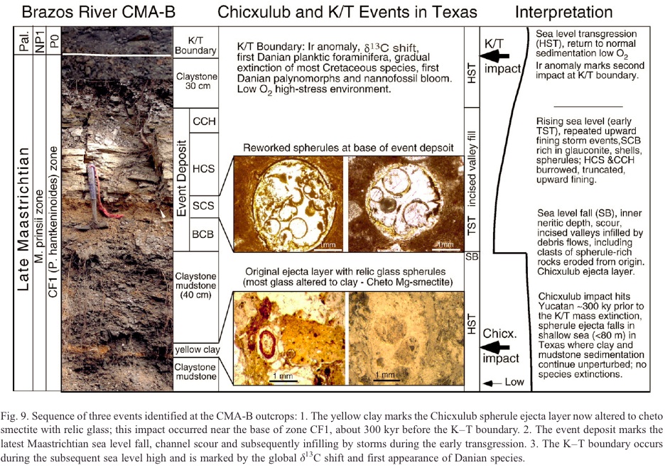
5. Sequence Stratigraphy
Sea-level change was not the major topic of our research report and was
only used in the discussion and summary Figure 9 to illustrate the depositional
environment of the Brazos sections [1]. Yet, Schulte et al. accuse us
of violating "well-established sequence stratigraphic concepts," then
launch into a lecture on sequence stratigraphy and sea level analysis
developed by Baum (one of the authors) and his colleagues at Exxon. They
seem shocked that anyone would propose a major sea level fall with a
concomitant subaerial unconformity in the late Maastrichtian, followed
by a sea level rise through the K/T boundary, yet this has been proposed
by various workers [40-44] (Baum pers. comm. to Schulte). The geochemical
profiles (stable isotopes, TOC) from the Brazos River cores and outcrop
are consistent with both relative and eustatic sea level
changes in the Brazos sections [45, 46]. They seem singularly
transfixed with Figure 9, centered around incised valleys and the use
of the terms transgression and maximum flooding surface (mfs). Concerning
the first issue, to our knowledge, none of the developers of sequence
stratigraphy ever gave width, length and depth dimensions as criteria
for incised valleys. In fact, many of the terms in sequence stratigraphy
were purposely "neuter" terms
related to geometries and not depositional processes. Moreover, Baum
and Vail [40] included incised valleys in both the lowstand and transgressive
depositional systems, and sometimes incised-valley-fill can be fairly
confidently differentiated [44]. Sometimes arguments ensue where two
different terms exist for the same thing or two disparate definitions
for the same word, such as transgression. According to Neuendorf et al.
[47], transgression can be defined as "spread or extension of the sea
over land areas." Jervey [48] has shown that eustatic sea level is rising
in the early highstand, but at a lower rate of rise. With this in mind,
the early highstand deposits are transgressing. But has the physical
stratigraphic framework at the Brazos localities changed or become "erroneous" because
transgression is defined differently by Schulte et al.? We think not.
Nowhere in our Figure 9 is mfs labeled, but is described in the text
as a burrowed omission surface. However, one could presume it to be between
TST and HST. Schulte et al. are confused on the meaning/definition
of mfs{1}. Baum and Vail [40] preferred to use the physical term, surface
of maximum starvation, to separate the transgressive and highstand
depositional systems and gave criteria for recognition. They understood
that, depending on the basin transect, eustatic sea level and paleo-water
depths (relative sea level) typically continue to increase above the
physically defined mfs [1, Fig. 9], before falling to the next unconformity/sequence
boundary. Not to add to Schulte et al.'s confusion, except for basin
floor fans, onlap occurs throughout a complete depositional sequence. |
| 2) But these criteria are nowhere
met in the Brazos river sections. The burrowing, spherule clasts and
so-called HCS are shown to be erroneous interpretations, so with these
criteria gone, there is no justification for this sealevel
interpretation. Culvers paper (in Keller et al 2007 referred to as support
for the shallowing of the Corsicana below the event beds) is nothing
but a compilation of Keller's earlier work, that has been severely criticized.
Other workers place a mfs about 5 m below the KT boundary at Brazos (Hoof
and Brinkhuis), and the next SB below the littig member (also Vail's
preference), about 3.5m above the KT boundary at Brazos-1 |